Dueling Town-by-Town Mid-Michigan Snowfall Predictions for December 11-12
The lake-effect snowfall predictions for Mid-Michigan are all over the place for December 11-12, depending on what forecast you're looking at.
The one thing all the forecasters seem to agree on: the state's about to experience the coldest weather it's seen since mid-January, with high temperatures not likely to escape the teens on Thursday.
SEE ALSO: Avoid a Ticket - Here Are Michigan's Snow Removal Laws
Let's compare forecasts from the National Weather Service and AccuWeather.
Here's What the National Weather Service is Forecasting
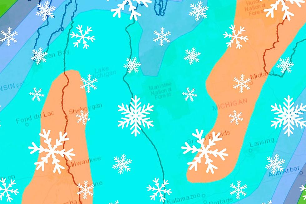
The National Weather Service has issued Winter Storm Warnings for counties all along the shore of Lake Michigan from Mackinac Island all the way to South Haven through Thursday evening. The warnings also extend further inland than the immediate shore counties in Northern Michigan, to include places like Gaylord and Cadillac.
According to the NWS, these warned areas could experience anywhere from 6-16" of snow by Thursday night.

Winter Weather Advisories for lesser snow totals have been issued east of the warned areas, to include places like Grand Rapids, Lansing, Kalamazoo and Jackson. Snow totals of generally less than 6" are expected in the counties where advisories have been issued.
Here's What AccuWeather Is Forecasting
Forecasters with AccuWeather are hedging their bets that we won't see quite as much snow in Mid-Michigan as the National Weather Service is thinking, although the expected totals in the shore counties and Northern Michigan are pretty much in line with each other.
SEE ALSO: The Unwritten Rules of Driving in Michigan Snowstorms
For his part, Meteorologist Justin Bradford with WILX News 10 in Lansing believes the difference in snowfall totals from town-to-town in Mid-Michigan will vary, but generally be below 6".
Most places can expect a broad 1-3″ from now through Thursday with 2-4″ and some locally higher amounts possible in any location where heavier lake effect snow banding happens to set up, though the greater accumulations will happen farther west in the state.
~ Meteorologist Justin Bradford, WILX News 10
Here's a town-by-town breakdown of the forecasts from both AccuWeather and the National Weather Service for nearly three dozen communities around Mid-Michigan.
TOWN-BY-TOWN SNOWFALL PREDICTIONS FOR DECEMBER 11-12, 2024
updated at 3:00pm on 12/11/24
| CITY | ACCUWEATHER | NATIONAL WEATHER SERVICE |
| Bath | < 1” | 2-3" |
| Charlotte | 1-3" | 3-5" |
| DeWitt | < 1” | 2-3" |
| Durand | Little to none | 1-2” |
| Eagle | 2-4” | 3-5" |
| East Lansing | < 1” | 2-4" |
| Eaton Rapids | < 1” | 3-5" |
| Elsie | < 1” | 1-2" |
| Fowlerville | < 1” | 3-4” |
| Grand Ledge | 2-4” | 3-5" |
| Haslett | < 1” | 2-3" |
| Holt | < 1” | 3-5" |
| Howell | < 1” | 3-4” |
| Ionia | 1-3" | 5-6" |
| Jackson | < 1” | 2-4" |
| Laingsburg | < 1” | 2-3” |
| Lansing | < 1” | 2-4" |
| Leslie | < 1” | 3-5" |
| Marshall | 1-3" | 3-5" |
| Mason | 1-2" | 3-5" |
| Nashville | 1-3" | 5-6" |
| Olivet | 1-3” | 3-5" |
| Onondaga | < 1” | 3-5" |
| Ovid | < 1” | 1-2" |
| Owosso | Little to none | 1-2” |
| Perry | < 1” | 2-3” |
| Portland | 1-3" | 3-5" |
| Potterville | 1-3" | 3-5" |
| St. Johns | < 1” | 2-3" |
| Stockbridge | < 1" | 2-3” |
| Vermontville | 1-3" | 3-5" |
| Webberville | < 1" | 2-3” |
| Westphalia | 1-3" | 2-4" |
| Williamston | < 1” | 2-3" |
12 Signs of a Cold and Brutal Michigan Winter
Gallery Credit: Canva
20+ Birds Around Michigan You'll See During The Winter
Gallery Credit: Tommy McNeill
More From 100.7 WITL